How This Project Started
As Robotics Head at RUGVED Systems, I inherited a vision: build an autonomous unmanned ground vehicle (UGV) for defense applications. WALRUS—Wireless Autonomous Land Recon Utility Service—wasn't just another college project. It was a multi-year, multi-subsystem effort that would teach me everything from ROS 2 navigation stacks to mechanical fabrication, from SLAM algorithms to system integration.
When I joined the team in October 2023, WALRUS was in its early stages. The scope was ambitious: an armored, autonomous UGV with payload capacity, AI turret capabilities, and landmine detection. Over two years, I'd go from learning ROS basics to leading the entire navigation system development, from CAD design to field testing.
The Problem We Wanted to Solve
Our inspiration came from studying the Indian Army Defense Compendium. We identified a critical problem: soldiers operating in rough, unstructured terrains need autonomous support systems that can navigate challenging environments, carry essential payloads, and operate when GPS is denied—a common scenario in defense operations.
WALRUS needed to solve real defense challenges: - Navigate complex, uneven, unstructured terrain without human intervention - Operate in GPS-denied environments with alternative navigation and tracking - Provide 3D navigation capabilities for rough terrain using cost-effective sensors (3D LIDAR was beyond budget constraints) - Carry modular payloads to support soldiers in war scenarios - Integrate with drone systems for coordinated multi-platform operations - Detect and avoid obstacles in real-time using camera-based and sensor fusion approaches - Map unknown environments while maintaining accurate localization without GPS
This wasn't a lab exercise. Every design decision had real-world implications for soldiers in the field. Every sensor choice affected weight, power consumption, and computational load. Every algorithm needed to work reliably in GPS-denied conditions, not just in ideal simulation environments.
System Architecture & Design
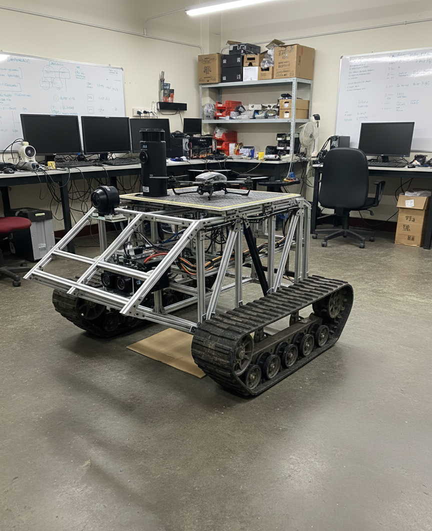
WALRUS 2.0 is built on a modular architecture that separates mechanical, electronic, and software subsystems while maintaining tight integration.
Core Components
Mechanical Framework: - Lightweight aluminum/steel chassis designed for uneven, unstructured terrain - Modular payload compartments for different mission configurations (medical supplies, ammunition, equipment) - Drone integration platform for coordinated UGV-drone operations - 360-degree AI turret mounting system - Robust suspension and wheel system for off-road capability - Modular design enabling rapid payload swapping and mission reconfiguration
Electronics Stack: - Jetson Nano as primary computing platform (upgraded from Raspberry Pi for computational requirements) - Motor drivers and ESCs for precise motion control - Power distribution system managing multiple voltage requirements - Sensor suite: LiDAR (A2 model), depth cameras, mono cameras for 3D perception, IMU, encoders - GPS module with GPS-denied navigation fallback systems
Software Architecture: - ROS 2 Humble as the middleware framework - Custom navigation stack integrating SLAM, path planning, and obstacle avoidance - 3D navigation algorithms for unstructured environments using camera-based depth estimation - GPS-denied navigation and tracking systems - Modular node structure for maintainability and testing - Simulation-first development approach using Gazebo and RViz with 3D terrain models
Hardware & Mechanical Aspects
CAD Design & Fabrication Journey
The mechanical design process was iterative. We started with a PVC frame prototype to validate basic movement and control before committing to the final metal structure. This approach saved us from costly mistakes and allowed rapid iteration.
Phase 1: PVC Prototype (Month 1-2) - Built initial frame from PVC pipes for testing - Validated motor mounting, sensor placement, and basic movement - Conducted stress testing to identify design improvements - Documented lessons learned before metal fabrication
Phase 2: Metal Frame Construction (Month 3) - Finalized CAD design based on PVC testing feedback - Fabricated lightweight aluminum/steel frame - Integrated motors, ESCs, sensors, and electronics - Validated stability under load and on various terrains
The CAD design had to be URDF-compatible for ROS simulation. This meant carefully defining all axes of rotation, joints, and connections to the parent chassis. The mechanical team and I worked closely to ensure the design translated seamlessly from CAD to simulation to physical robot.
Material Selection & Weight Optimization
Every component choice affected the overall system. We optimized for: - Weight: Critical for mobility and power consumption - Strength: Required for payload capacity and terrain traversal - Modularity: Needed for different mission configurations
The fabrication process involved coordination with workshop facilities, material procurement, and iterative assembly. By Month 6, we had a robust physical platform ready for advanced sensor integration.
Electronics & Embedded Systems
Sensor Integration
LiDAR Integration: We selected the A2 LiDAR model to reduce weight and computational complexity. The RPi LiDAR solution proved suitable for our needs, providing: - Real-time obstacle boundary detection - Mapping capabilities for SLAM - 360-degree environmental awareness
Integration involved setting up the LiDAR driver node in ROS 2, processing raw sensor data into ROS messages, and calibrating coordinate frame transformations. The visualization in RViz was crucial for debugging and understanding what the sensor was seeing.
IMU & Encoder Integration: Motor encoders provided wheel odometry, essential for pose estimation. Combined with IMU data, we achieved accurate robot localization. The integration required: - Understanding encoder specifications and data formats - Implementing odometry calculation algorithms - Coordinate transformation for proper frame alignment - Calibration for accurate measurements
Camera Integration for 3D Navigation: Since 3D LIDAR was beyond our budget constraints, we developed a camera-based 3D navigation system for unstructured environments. This involved: - Stereo camera setup for depth estimation - Depth camera integration for 3D perception - Camera driver configuration in ROS 2 - 3D point cloud generation from camera data - Real-time 3D obstacle detection and terrain analysis - Integration with navigation stack for 3D path planning

The 3D navigation system enabled WALRUS to understand terrain elevation, detect obstacles in 3D space, and plan paths through rough, unstructured environments—all using cost-effective camera sensors instead of expensive 3D LIDAR.

Computing Platform: Jetson Nano
The transition from Raspberry Pi to Jetson Nano was driven by computational requirements. The navigation stack, SLAM algorithms, and computer vision processing needed more processing power. The Jetson Nano provided: - GPU acceleration for computer vision tasks - Sufficient CPU power for real-time navigation - ROS 2 compatibility - Power efficiency for field operation
Integration involved setting up the Jetson environment, optimizing ROS 2 performance, and ensuring reliable operation under load.
Software, Control & AI
ROS 2 Navigation Stack
The navigation system was the heart of WALRUS's autonomy. I developed a custom navigation stack that integrated multiple components:
SLAM Implementation: We implemented Gmapping for real-time environment mapping. The process involved: - Understanding probabilistic SLAM algorithms - Configuring parameters for our robot's specifications - Tuning for optimal map quality and localization accuracy - Achieving ~90% localization accuracy (targeting 95%+)
The initial implementation worked in simulation, but real-world testing revealed challenges. Sensor frame transformations needed correction, and parameter tuning was time-consuming but essential.
Path Planning: Integrated path planning algorithms including: - A\*: For global path planning to specified destinations - DWA (Dynamic Window Approach): For local obstacle avoidance and dynamic path adjustment
The path planner needed to work in real-time, avoiding obstacles while navigating to goals. Testing in various environments with different obstacle configurations validated the system's robustness.
Obstacle Avoidance: Real-time obstacle detection using LiDAR and camera-based 3D perception, processed and integrated with the navigation stack. The system could: - Detect obstacles dynamically in 3D space - Adjust path in real-time - Handle complex, unstructured terrain with multiple obstacles - Understand terrain elevation and plan accordingly
GPS-Denied Navigation & Tracking: A critical requirement from the Indian Army Defense Compendium was operating in GPS-denied environments—common in defense scenarios. We developed alternative navigation and tracking systems: - Visual SLAM for localization without GPS - Landmark-based navigation using camera systems - Dead reckoning using IMU and encoder fusion - Visual odometry for position estimation - Integration of multiple sensor modalities for robust navigation
This GPS-denied capability was essential for real-world defense applications where GPS signals can be jammed or unavailable.
Lane Detection System
For structured environments, I developed a lane detection system using OpenCV: - Color Masking: HSV color space filtering for yellow and white lanes - Edge Detection: Canny edge detector for lane boundaries - Hough Transform: Line detection for lane marking identification - ROI (Region of Interest): Focused processing on relevant image regions
The algorithm needed real-time performance and robustness to different lighting conditions. Integration with the navigation system allowed the UGV to follow lanes when available, falling back to general navigation otherwise.
Drone Integration Platform
WALRUS was designed with drone integration capabilities for multi-platform missions. The system includes a secure landing platform on the UGV chassis, docking mechanism for autonomous resupply, and power and data connections for drone charging and data transfer.

The drone integration enables shared sensor fusion, with the drone providing aerial reconnaissance while the UGV handles ground operations. This creates a comprehensive robotics system capable of both ground and aerial missions.
Modular Payload System
Inspired by the Indian Army Defense Compendium's requirements for supporting soldiers in rough terrains, we designed a modular payload system:
Payload Compartments: - Modular compartments for different mission types - Medical supplies for field support - Ammunition and equipment transport - Rapid payload swapping for mission reconfiguration - Secure mounting for various payload types
Mission Configurations: - Medical support missions: Carrying medical supplies to soldiers in remote locations - Supply missions: Transporting essential equipment and ammunition - Reconnaissance missions: Sensor payloads for intelligence gathering - Combat support: Integration with AI turret and weapon systems
The modular design enabled WALRUS to adapt to different mission requirements quickly, supporting soldiers in various operational scenarios.
Simulation Environment
Extensive simulation work in Gazebo and RViz was crucial for development: - Created virtual environments replicating rough, unstructured terrain scenarios - Tested 3D navigation algorithms in simulated uneven terrain - Validated sensor configurations and parameters - Simulated GPS-denied scenarios for navigation testing - Tested drone integration platform

The simulation-first approach accelerated development and reduced hardware wear during testing. URDF compatibility ensured the simulation accurately represented the physical robot, including 3D terrain navigation capabilities.
Testing, Failures & Fixes
Early Challenges
SLAM Localization Issues: Initial real-world SLAM testing revealed poor localization accuracy. The problem? Incorrect sensor frame transformations. Fixing coordinate frame issues improved map generation significantly, but parameter tuning remained an ongoing process.
Sensor Integration Problems: Each sensor integration brought its own challenges. LIDAR data format complexity required careful processing. Encoder data needed proper calibration. Camera integration required performance optimization for real-time operation.
Frame Transformation Debugging: Understanding ROS coordinate frames (base_link, odom, map) was crucial. Incorrect transformations caused navigation failures. Visualizing frames in RViz and carefully validating transformations solved these issues.
Iterative Testing Process
Testing followed a systematic approach: 1. Simulation Testing: Validate algorithms in Gazebo 2. Component Testing: Test individual sensors and subsystems 3. Integration Testing: Validate system-level behavior 4. Field Testing: Real-world validation in various terrains
Each phase revealed issues that required fixes and iteration. The process was time-consuming but essential for reliability.
Performance Optimization
Achieving real-time performance required optimization: - Algorithm efficiency improvements - Computational resource management - Sensor data processing optimization - Navigation stack parameter tuning
The goal was reliable operation under field conditions, not just lab performance.
Results & Achievements
Navigation System Completion
By March-May 2024, the navigation system was complete: - SLAM working with ~90% localization accuracy - Path planning (A* and DWA) functional - Obstacle avoidance operational - Integration with all sensors validated
System Integration
- UGV chassis and framework completed
- LiDAR sensors integrated and tested
- Jetson Nano integration completed
- Vision camera integration completed
- Extensive simulation validation in Gazebo and RViz
Project Status
As of the latest updates, WALRUS 2.0 has: - Completed navigation system - Fabricated and integrated mechanical framework - Integrated sensor suite - Validated in simulation and initial field tests - Ongoing development for AI turret and landmine detection subsystems
What I Learned Leading This
Leading WALRUS development taught me that robotics is fundamentally about systems thinking. Every component affects every other component. A sensor placement decision impacts weight distribution, which affects power consumption, which influences algorithm performance.
The project also taught me the importance of working within budget constraints while maintaining capability. Developing 3D navigation using cameras instead of expensive 3D LIDAR required creative problem-solving and algorithm development. This constraint-driven innovation resulted in a cost-effective solution that met our requirements.
Studying the Indian Army Defense Compendium and understanding real-world defense challenges gave the project purpose beyond technical achievement. Every design decision was evaluated against the question: "Will this help soldiers in the field?" This real-world focus drove better engineering decisions.
Technical Learnings: - ROS 2 architecture and best practices - SLAM algorithms and parameter tuning - 3D navigation using camera-based depth estimation - GPS-denied navigation and alternative localization methods - Sensor integration and calibration - Multi-platform system integration - Modular system design for mission flexibility - System integration challenges - Simulation-to-reality gaps - Budget-constrained innovation
Leadership Learnings: - Coordinating multiple subsystems - Managing timelines and deliverables - Balancing technical depth with project progress - Knowledge transfer to team members - Strategic planning and resource allocation
Process Learnings: - Simulation-first development accelerates progress - Iterative testing catches issues early - Documentation is crucial for continuity - Modular design enables parallel development
Future Directions
WALRUS 2.0 continues to evolve. Planned enhancements include:
AI Turret Integration: - Computer vision algorithms (YOLO) for threat detection - Autonomous target tracking and engagement - Safety protocols for autonomous firing
Landmine Detection: - Research into detection technologies (ground-penetrating radar, metal detectors) - Sensor integration and calibration - Field testing and algorithm refinement
Advanced Features: - Enhanced 3D navigation algorithms for more complex terrain - Improved GPS-denied navigation robustness - Advanced drone integration capabilities - Communication systems (LoRa/XBee) for long-range control - Encrypted communication protocols - Autonomous resupply and payload swapping mechanisms - Enhanced payload management system - Field testing in actual rough terrain conditions
Competition Preparation: - IGVC competition preparation - Field trials in varied terrain conditions - Performance optimization for competition scenarios
The project represents a comprehensive autonomous robotics system, integrating mechanical design, electronics, and software into a cohesive platform. The lessons learned here apply to any complex robotics project: start with simulation, test iteratively, integrate carefully, and always think about the system as a whole.
---
WALRUS 2.0 represents two years of development, integration, and learning. From ROS basics to leading a multi-subsystem project, this UGV taught me that autonomous robotics is as much about systems engineering as it is about algorithms.